


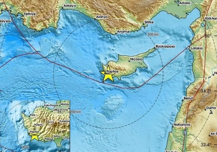
An earthquake measuring approximately 5.7 on the Richter scale was felt across Cyprus. The tremor serves as a reminder of Cyprus’s location in an active seismic zone, where historical records show the island has been struck by powerful earthquakes throughout the centuries.
Cyprus has been shaken throughout the ages, evidenced by historical references and archaeological findings showing the island was struck by powerful earthquakes in the past, which in many cases destroyed its cities.
Historical data shows that 20 destructive earthquakes occurred between 26 BC and 1900 AD.
According to statistics from the Geological Survey Department, approximately every 153 years the Cyprus region is struck by an earthquake exceeding magnitude 7 on the Richter scale.
Every 52 years it is hit by an earthquake greater than 6.5, every 17 years it is shaken by an earthquake exceeding 6, every six years by an earthquake surpassing 5.5, and every two years by an earthquake greater than 5.
These earthquakes are not the only ones, as the department’s seismological centre records on average at least 2,000 earthquakes annually, of which 1,300 have epicentres in the wider Cyprus region. Of these, only 0.5% are felt by citizens.
1953 earthquake killed 40 people
The most recent destructive earthquake occurred on 10 September 1953, killing 40 people. A hundred were injured and 4,000 left homeless. Some 158 villages and towns were affected. Strong earthquakes followed in 1995, 1996 and 1999, confirming in practice that Cyprus is located in a seismic zone.
According to the Geological Survey Department, Cyprus is situated in the Alpine-Himalayan seismic zone, where 15% of global earthquakes occur.
Cyprus’s seismicity is primarily attributed to the “Cyprus Arc”, which constitutes the tectonic boundary between the African and Eurasian lithospheric plates in the Eastern Mediterranean region.
The African plate moves northward towards the Eurasian plate, resulting in collision and subduction of the African plate beneath the Anatolian microplate, part of the Eurasian plate where Cyprus is located.
The Cyprus Arc is primarily divided into three sections, with its western section located west of the Akamas peninsula displaying the most intense activity with intermediate-depth earthquakes up to 130 kilometres.
The central section appears south of Cyprus and also shows intense seismicity, mainly with shallow earthquakes. The eastern section, also referred to as the “Latakia Fault”, shows low seismicity with an absence of intermediate-depth earthquakes, possibly due to inactive subduction.
Cyprus’s most intense seismicity is observed in the central-western part of the Cyprus Arc and in onshore faults in Paphos, Limassol and Larnaca.
Building safety concerns
Based on these data, humanity’s primary defence is constructing buildings and infrastructure that can withstand earthquakes or at least do not collapse easily, avoiding large numbers of casualties as occurred with older earthquakes, mainly in other countries.
One could say that after 1994, when the Cypriot anti-seismic regulations came into force, buildings are constructed with better specifications and are generally more resistant, provided relevant terms and conditions are met, supervision exists, and appropriate materials are used.
Theoretically, since 2012, when Eurocodes concerning earthquakes were implemented, buildings have been constructed to be even more earthquake-resistant.
However, buildings constructed after 1996 are not the only ones. Tens of thousands of buildings were constructed previously and were already stressed by major preceding earthquakes.
They withstood them, but the earthquakes are considered to have left their mark, even if the damage caused was not extensive. After the major 1996 earthquake, approximately 10,000 structures showing minor or major damage were inspected, though most damage was minor.
All this creates the need to inspect buildings to determine where they stand from a structural perspective.
Taking into account the total cost to the state and taxpayers from extensive destruction in case of a destructive earthquake, a middle ground must be found, even with subsidies for inspections of buildings belonging to vulnerable groups.
Inspection of public-use buildings such as cinemas, churches, stadiums, large department stores, reception halls, schools, hotels and generally spaces where large numbers of people or workers gather is also considered essential.
Active faults remain
Cyprus has active faults that continue to cause earthquakes.
In the Akrotiri area, many small faults are estimated to exist which are not considered capable of causing large-magnitude earthquakes.
The Gerasa fault, located relatively close to the Akrotiri faults, can cause a major earthquake. On 11 August 1999, the Gerasa fault caused a magnitude 5.6 earthquake on the Richter scale.
The strong earthquake, with its epicentre at Gerasa village, was felt intensely across the island. It caused damage to buildings in Limassol and villages in the northern part of the district. A total of 40 people were slightly injured due to panic.
A large number of aftershocks continued for many months. The 25-kilometre Gerasa fault is the only active fault in Cyprus, split into two sections of 10 and 15 kilometres respectively.
Faults exist in other Cyprus regions, including the Ovgos fault in Nicosia, the Kythrea fault and two other faults in Paphos. The Ovgos fault runs beneath Nicosia and is associated with earthquakes up to magnitude 4.5 on the Richter scale.
According to the Geological Survey Department, Cyprus’s largest fault was the Arakapas fault, which is now inactive. The Arakapas fault, also called a transform fault, was created 80 million years ago when Cyprus was still under the sea and later became inactive.
Recent historical earthquakes
The most recent historically significant earthquakes include:
- 23 February 1906: Strong 5.3 magnitude earthquake felt across the island, causing significant destruction in Limassol-Kolossi
- 10 September 1953: Magnitude 6 destructive double earthquake in Paphos district killing 40 people, injuring 100 and leaving 4,000 homeless, affecting 158 villages and towns
- 23 February 1995: Destructive magnitude 6.1 earthquake in Paphos district with two deaths, with several houses collapsing in Pano Arodes and Miliou villages
- 9 October 1996: Magnitude 6.5 earthquake with two deaths from secondary causes and 20 slightly injured
- 11 August 1999: Magnitude 5.6 earthquake with epicentre at Gerasa village
- 15 April 2015: Magnitude 5.6 earthquake with epicentre in the sea west of Kissonerga in Paphos
Read more:

